


venelles la ferte saint aubin

lemuid
User
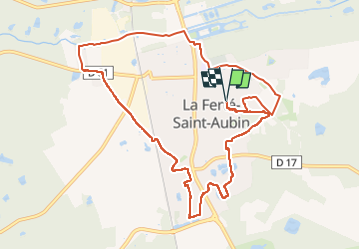

Length
11 km

Max alt
134 m

Uphill gradient
92 m
Km-Effort
12.2 km

Min alt
99 m

Downhill gradient
92 m
Boucle
Yes
Creation date :
2024-11-16 08:04:36.942
Updated on :
2024-11-16 17:38:23.562
2h47
Difficulty : Very easy

FREE GPS app for hiking
 SityTrail
IGN / Geographical institutes
SityTrail Plus
The world is yours!
About
Trail Walking of 11 km to be discovered at Centre-Loire Valley, Loiret, La Ferté-Saint-Aubin. This trail is proposed by lemuid.
Positioning
Country:
France
Region :
Centre-Loire Valley
Department/Province :
Loiret
Municipality :
La Ferté-Saint-Aubin
Location:
Unknown
Start:(Dec)
Start:(UTM)
421012 ; 5285538 (31T) N.
Comments